Images (c) by James L. Reveal, Norton-Brown Herbarium, University of Maryland, unless otherwise credited.


BSCI 124 Lecture Notes

Department of Plant Biology, University of Maryland

LECTURE 35 - TERRESTRIAL BIOMES


Montane coniferous forest near Kebler Pass, Colorado


I. Introduction

The North American continent is the home of a diverse array of plants and animals all occupying a multitude of ecological sites in a variety of climatic regimes. The biota of North America - the sum total of its living creatures - when considered in relation to climatic, soil and physiographic features allows biologists to recognize grand associations that are termed biomes.

The purpose of the two lectures on biomes is to provide the student with an awareness of life from the arctic to the tropics. Our goal is to make you, the young men and women who are the future, cognizant of the living creatures, the land, and the environment of the planet.

To understand the present flora, it is useful to understand in broad terms the fate of the flora over the last 18,000 years. The flora of North America has changed significantly insofar as its distribution is concern during this short period of time in the earth's history. A large mass of ice dominated much of the northern third of the continent. Unglaciated regions in Alaska allowed not only numerous plants and animals to survive in refugia, but provided a broad avenue for people to enter onto a new land. Much of the native flora was compressed in front of the ice sheet, the vast taiga of today was little more than a narrow strip along the front and down the backbone of the Appalachian Mountains.

The eastward expansion of the eastern coast of the United States onto the Atlantic ocean shelf, and especially around Florida, proved to be an escape route for species to survive. In the West, deserts were more southerly, and the grasslands more compact.

By 8,000 years ago, a vast warming trend had significantly reduced the size of the ice sheet, with the tundra and taiga expanding rapidly northward as the ice retreated. On the Great Plains, the grasslands moved northward, the southern tip being equally rapidly replaced by desert conditions. In the West, cold desert vegetation expanded northwardly to a degree, but mainly elevation up slope and, in the Great Basin, onto the floors of the now dried pluvial lake beds.

Present-day biomes were rapidly establishing starting some 5,000 years ago as the climate cooled to its present norm. The tundra continued to move northward, expanding onto the Arctic slope as the ice continued to melt. The taiga proved to be an effective barrier to the northward expansion of both the grasslands of the Great Plains and the deciduous forest in the East.

In the west, the Chihuahuan and Mojave deserts became established in their present position, and the northward expansion of the Sonoran Desert was halted by a combination of cooling climates and topography. The rapid desertification in the West, coupled with the survival of plants and animals in small refugia or nunataks resulted in a diverse modern flora.

Diversity in terms of species is far greater in the American West and the Deep South, where the sheer force of the ice sheet was less compared to that in the Northeast and most of Canada. The geologically ancient flora of the Southeast survived by virtue of its position on the continent; that of the West underwent rapid and profound speciation resulting in a multitude of kinds.


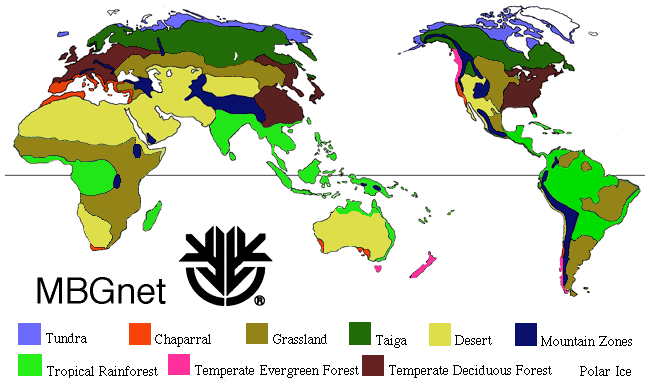
Biome map of the world from Missouri Botanical Garden


For a map of the biomes of North America, see this site

II. Definitions & Role of Climate

  1. Definition
    1. Biogeography: the study of animal and plant distributions; known as zoogeography and phytogeography, respectively.
    2. Biome: any one of the several major ecosystems which may be characterized by the presence of specific plants and animals, climate, and soil conditions in a specific geographic setting. In terms of area, it is composed of several plant communities and ecosystems. The boundary between biomes is termed an ecotone and may be important in our understanding of speciation and dispersal. Many plants in a given biome may be an endemic, that is found no where else in the world; biological diversity differs considerably between biomes.
    3. The biomes of North America are: (1) tundra, (2) taiga, (3) montane forests, (4) temperate rain forests, (5) mixed conifer and sclerophyllous hardwood forests, (6) temperate deciduous forests, (7) chaparral, (8) grasslands, (9) deserts, (10) tropical forests.
    4. The world as a whole is often divided into six biogeographic kingdoms:
      1. Boreal kingdom
      2. Paleotropical kingdom
      3. Neotropical kingdom
      4. South African kingdom
      5. Australian kingdom
      6. Antarctic kingdom
  2. Role of Climate
    1. Biomes controlled by climate: extremes of temperatures and precipitation more significant than averages.
    2. Daily and seasonal cycles influence prevailing winds.
      1. Climate is global and is ever changing.
      2. Important features include the jet stream and the associated cloud patterns as well as ocean currents; the seasons of the year are determined by the tilt of the earth.
      3. Weather moves west to east in North America.
      4. Precipitation influenced by physiographic features - distribution, size and height of mountain ranges, locations of oceans, etc., the amounts differing from biome to biome.
    3. Elevation
      1. Biomes at higher elevations in more southern latitudes.
      2. With sufficient elevation, numerous biomes can be found on a single mountain range.
      3. Often subdivided into "life zones".
    4. Change over time
      1. Climatic changes over last 21.000 years.
      2. Tectonic plate movement over long periods of time.


    Frozen tarn pond in alpine tundra near Dillon, Colorado


III. Tundra

  1. Location:
    1. Northernmost and circumpolar in northern hemisphere.
    2. Northern Alaska and Canada, all of Hudson Bay in east.
  2. Features:
    1. Dry: (6-14 in or 15-35 cm) as summer and fall cold rains.
    2. Cold: Freezing temperature can occur any day of the year and temperatures rarely exceed 15° C even during the warmest of months. The growing season varies from 60 to 100 days a year.
    3. Soils: Wet, shallow, often frozen or with permafrost; shallow lakes, known as polygons
    4. One physical feature of the region (both here and in the montane biome) is the force of glaciation caused by a glacier. Glaciers are particularly impressive and massive in Antarctica. The consequences of past glaciation may be seen in the Sierra Nevada of California - see image.
    5. Vegetation:
      1. Low shrubs and herbs, mostly graminoids - grass-like plants.
      2. Some 700 species.
      3. Defined by a distinct tree line
    6. Animals:
      1. Migratory birds, especially water birds.
      2. Predators: wolves, arctic fox, weasels, owls, etc.
      3. Large mammals: bear, caribou (New World) or rain deer (Old World), musk oxen, polar bear and Dall sheep.
      4. Small mammals: voles, lemmings
      5. Insects: Black flies, mosquitoes, gnats
      6. Low diversity and productivity
    7. History:
      1. Most (but not all) of the area dominated by last continental ice sheet ("Laurentide Ice Sheet"); effects ended about 4000 years ago.
      2. Vegetation moved northward forming "high" and "low" tundra.
    8. Exploitation:
      1. Habitat destruction due to exploitation of natural resources.
      2. This "frozen" or "polar desert" requires centuries to recover.
      3. Possible impact from global warming which is having a greater impact in the tundra than elsewhere.
      4. Threat of pollution.


    Southern Taiga Forest or Boreal Forest - Michigan


    IV. Taiga

    1. Introduction: The boreal (meaning northern) forest region occupies about 17 percent of the Earth's land surface area in a circumpolar belt
    2. Location:
      1. Circumpolar in northern hemisphere.
      2. Alaska and Canada to northeastern and Great Lakes region of the United States.
      3. Area often characterized as "boreal forest", "northern coniferous forest" or "Cold Climate Forest".
    3. Features:
      1. Forest dominated by densely arranged dark evergreen conifers; an effective "carbon sink".
      2. Little moisture (17-20 in or 40-50 cm) mostly as summer rains.
      3. Freezing temperature, extreme cold (-100° F are not uncommon). The temperature rarely exceeds 85° F in the summer. The growing season is 90 to 120 days per year. Snow is common.
      4. Shallow soils, wet, deep permafrost; nutrient poor.
      5. Fire is an occasional factor.
    4. Vegetation:
      1. Northern edge defined by a timberline
      2. Trees include both softwoods (conifers) and hardwoods (flowering plants)
      3. Other plants: Shrubs include willows and members of the heath family (Ericaceae) but not Erica the true heath.
      4. Graminoids (mainly grasses), lichens and bryophytes (Sphagnum).
      5. Succession: Shallow ponds or lakes to peat bogs to graminoids to shrubs to trees.
      6. About 1800 species of vascular plants
    5. Animals:
      1. Large mammals: Elk, caribou, deer, bear (brown, grizzly).
      2. Predators: Wolves, bear, lynx, wolverine, fox.
      3. Birds: Migratory and some resident birds, especially song birds.
      4. Insects: black flies, midges, gnats and mosquitoes
    6. History:
      1. Most of the biome covered by repeated series of continental ice sheets, the most recent being the Wisconsin Ice Sheet which reached its height about 25,000 years ago, persisted until about 12,000 years ago, and declined over the period 10,000-7,000.
      2. Ancient Lake Agassiz existed before the present-day Great Lakes
      3. Refugia (sing. refugium): areas where plants and animals escaped the effects of glaciation; land bridge across the Bering Straits between Siberia and Alaska, "islands" as in central Alaska and the "driftless" area of Wisconsin, and escape routes along the Pacific coast of Alaska.
      4. Nunataks: Isolated mountain tops or ridges that were unglaciated; resulted in many endemic and disjunct populations
    7. Exploitation:
      1. Hunting is leading to a loss of many species, especially fur-bearing animals.
      2. Mineral exploitation resulting in habitat loss and pollution.
      3. Fire: mainly natural and part of the succession process.
      4. Lumbering: may be a threat in the near future.
      5. Productivity limited by cold and varies greatly throughout the region


    Montane Coniferous Forest, Wind River Mountains -- Wyoming


    V. Montane Forests

    1. General features
      1. Most complex biome in North America; widespread in the world.
      2. Fragmented in three major montane cordillera, each with a distinct fauna and flora; composed of many subcommunities or associations.
        1. Appalachian Mountains
        2. Rocky Mountains
        3. Sierra Nevada-Cascade Ranges
      3. General trending north/south, high elevation.
      4. Moist west slope, dry eastern slope - rain shadow effect.
      5. Influenced by recent glacial events; refugia and/or escape routed.
      6. Composed primarily of conifer species; often with some hardwoods
      7. Fire is often a major factor.
      8. Temperatures warmer than tundra, but often as cold and much more windy.
    2. Appalachian Mountains
      1. Location: Higher mountains and ridges stretching from Vermont and New Hampshire to the Smoky Mountains of Tennessee and North Carolina.
      2. Features:
        1. Conifers and deciduous hardwoods.
        2. Elevations most 2600-6000 ft (800-1800 m)
        3. Cool; average winter temperature is about 23° F, average high for the warmest month around 60° F. Extremes can reach -30° F and more than 100° F.
        4. Precipitation 60-100 in (150-255 cm); snow and rain; summer snow rare.
        5. Soils shallow and often over bedrock.
    3. Rocky Mountains
      1. Location: A massive complex from northern Alberta, Canada, to New Mexico, defined by the Great Plains in the east, western edge less sharply demarcated. North of South Pass, Wyoming, termed the "Canadian Rockies" to the south "Colorado Rockies." Includes isolated ranges in Idaho and Utah.
      2. Features:
        1. Numerous conifers and some deciduous hardwoods
        2. Numerous ranges over 13,000 ft (4000 m) in elevation; "parks" - broad valley bottoms - occur above 9000 ft (2750 m).
        3. Well-marked timberline.
        4. Precipitation (15-60 in or 40-150 cm) falls mainly as winter snow. Dry summers with lightening storms
        5. Variable soils.
        6. Heavily glaciated with localized ice caps; glaciers and snow fields present today; numerous refugia and nunataks formed.
        7. Timberline has changed latitudinally and elevationally over time.
        8. Hot, rapid fires have played a major role; "crown fires" can created their own fire storm.
    4. Sierra Nevada-Cascade Ranges
      1. Location:
        1. Sierra Nevada: continuous mountain range restricted to California and the Lake Tahoe region of Nevada.
        2. Cascade Ranges: southern Oregon to British Columbia as a series of fragmented, volcano-dominated montane islands; transitional ranges join the two in northern California.
      2. Features:
        1. Large conifers of numerous and diverse kinds, many deciduous hardwoods.
        2. Many peaks over 14,000 ft (4270 m).
        3. Cool, moist winters and seasonable summers.
        4. Precipitation mainly as winter snows, 10-50 in (25-125 cm).
        5. Variable soils; granitic and volcanic soils common.
        6. Great diversity of plants and animals, many endemics.
        7. Fire a significant factor with many species adapted to fire.
        8. Gentle, moist western slope; steeper, drier eastern slope.
        9. Numerous volcanic peaks (e.g., Mount Rainier and Mount St. Helens).
    5. Vegetation
      1. Mostly dense stands of conifers with scattered hardwoods
      2. Many shrubs mainly in moist areas
      3. Scattered meadows with a diversity of graminoids.
    6. Exploitation
      1. Logging, especially in the Appalachian Mountains, most climax forests now cut
      2. Recreation pressures increasingly a threat, especially to the herbaceous flora

    VI. Temperate Rain Forest

    1. Location: Pacific Coast from southern Alaska to central California.
    2. Features:
      1. Mostly coastal and in low mountains (less than 9,000 ft)
      2. Abundant precipitation, rain and snow; 25-160 in (65-400 cm).
      3. Cool temperatures, rarely below 5° F or above 100° F; moister and cooler in the north. Fog an important component.
      4. Soils are deep and rich but mineral poor.
      5. Fire can be significant albeit usually not devastating to larger trees.
      6. A fair diversity of plants and animals.
    3. Vegetation:
      1. Diversity of conifers and hardwoods, many tall and old. Pines, fir, spruce, redwood and Douglas fir. Old growth forest was common; now reduced to about 10% of original.
      2. Numerous species of shrubs and wild flowers. Many endemic.
    4. Animals:
      1. Numerous resident birds and animals.
      2. Some fur-bearing species (seal and otter) were common.
    5. History:
      1. Ancient, relictual forest, many "living fossils" - plants whose ranges were once much more widely distributed.
      2. Many related plants also found in Southeast Asia.
      3. Position of forest not affected by Pleistocene glaciation
      4. Many species adapted to slow burning fires (thick bark of redwood).
    6. Exploitation:
      1. Lumbering has dramatically reduced the extent of the forest; "clear-cutting" generally no longer practiced.
      2. Fire suppression in recent years has increased losses due to wild fire.

VII. Mixed Conifer and Sclerophyllous Hardwood Forests

  1. Location: mountains of northern Mexico, and most notably that found in the Sierra Madre Occidental and Sierra Madre Oriental.
  2. Features:
    1. Warm seasonal rains, some snow; mostly 30-50 in (75-150 cm)
    2. Moderate temperatures, but freezing temperatures in arid alpine zones atop volcanic peaks in the "trans-volcanic belt"
  3. Vegetation:
    1. Mixture of numerous species of conifers and hardwoods
    2. Many hardwoods and large shrubs (to 30 ft high) with small ("microphyllous"), leathery ("sclerophyllous"), often evergreen leaves.
  4. Animals: Mixture of temperate and subtropical forest and desert species.
  5. Exploitation: Historically an area of small farms and limited grazing with some mining (generally without erosion or pollution control); now being intensively cut for timber.


Fall foliage near the University of Maryland Campus, Maryland


VIII. Temperate Deciduous Forests

  1. Location: Eastern portion of North America. Bounded on the east by the coastal plain along the Atlantic Ocean, the Great Plains on the West, the taiga in north and the Gulf of Mexico in the south.
  2. Features:
    1. Composed of numerous, well-defined vegetation associations dominated by deciduous trees and shrubs.
    2. Variable climate, warmer and wetter in the south
      1. Precipitation 30-60 in (75-150 cm) annually, mostly as rain
      2. Growing season of 120 (Canada) to 250 (Florida) days.
      3. Temperature extremes can be significant: -20 to -40° F to 100 to 110° F.
      4. Hurricanes and freezing rain can cause considerable physical damage to the vegetation.
      5. Soils more acid and fertile in north.
    3. Composed primarily of hardwoods with a mixture of conifers.
    4. Fire a major factor in maintaining the forest and diversity of herbs and shrubs on the forest floor
    5. Biome once wide spread across all of North America and Eurasia; flora similar to that of China today.
  3. Vegetation:
    1. Variety of hardwoods: Quercus (oak), Acer (maple), Fagus (beech), Tilia (basswood), Castanea (chestnut), and Carya (hickory). Tulip poplar (Liriodendron) also common.
    2. Scattered conifers mostly pines.
    3. Numerous shrubs, many of the heath family (e.g., Rhododendron (left), Kalmia; blueberries (Vaccinium) also common.
    4. Numerous grasses and wild flowers throughout the growing season.
  4. Animals:
    1. Mammals: Deer; moose and bear were common; historically buffalo in the area. Raccoon and opossum common, so are skunks.
    2. Predators: Fox common; bobcat or lynx rare; wolves and mountain lion extirpated.
    3. Birds: Resident and migratory; numerous song birds and waterfowl.
  5. History:
    1. Only northern section directly glaciated; vegetation pushed southward into northeastern Mexico and out onto what is now the continental shelf as sea levels were lower than at present.
    2. Southeast flora not subject to extensive extinction so many relictual genera and species still persist.
    3. Chesapeake Bay and Great Lakes began to form some 10,000 years ago.
    4. Pine Barrens of New Jersey not affected by glacial epoch and flora remained in place.
    5. Isolated pockets of montane forest vegetation on coastal plains.
  6. Exploitation:
    1. No undisturbed forest present today due to extensive logging.
    2. Introduction of Chinese chestnut into New York Zoological Garden resulted in a fungal disease that destroyed the American chestnut.
    3. Clear-cutting of forest for farming coupled with introduction of exotic weed species has fundamentally altered the flora.
    4. Soil erosion and depletion has made it difficult for some species to re-invade disturbed sites.
    5. Erosion has resulted in silting and deposition in wetlands; some 90% of the wetlands in Maryland have been destroyed.
    6. Numerous species of plants and animals have gone extinct or have been extirpated over significant portions of their native range.

IX. Chaparral

  1. Location: Coastal southern California and northern Baja California, Mexico. Widely scattered elsewhere in the world: southern Europe and northern Africa, Cape Region of southern Africa.
  2. Features:
    1. Dominated by microphyllous (small), sclerophyllous (e.g. leathery), xerophytic (dry) evergreen shrubs and a mixture of low conifers and hardwood trees.
    2. Climate: Cool and wet in winter; hot and dry otherwise.
      1. Precipitation as rain in late Nov to early Apr, 14-29 in (35-75 cm); falls as rain or rarely as snow.
      2. Seasonally warm in winter, hot in summer, frost infrequent, can exceed 110° F.
    3. Slope and exposure critical; moist north-facing, dry south-facing; slopes usually steep.
    4. Hot winds and fire frequently occur in late fall at end of dry season.
    5. Generally poor soils, shallow and rocky.
    6. Fire climax community.
  3. Vegetation:
    1. Dominant shrubs are chamise (Adenostoma fasciculatum), California buckwheat (Eriogonum fasciculatum), various species of manzanita (Arctostaphylos), and (at higher elevations) species of ceanothus (Ceanothus).
    2. Dominant trees are oaks (Quercus) and pines (Pinus).
    3. Many endemic species of wildflowers; flowers most common from March to June.
    4. Many species have volatile oils in the leaves meaning that they burn rapidly.
    5. Many species specially adapted to repeated burning (e.g., root crowns ("lignotuber") from which new shrubs can grow; cones of pines ("cone serotiny") that require high heat to open.
  4. Animals:
    1. Diversity of birds, especially ground birds, deer and small mammals.
    2. Many species of both plants and animals are narrowly endemic.
  5. History:
    1. Chaparral a more southern biome, moved to its present position during Pliocene and Pleistocene times, becoming less expansive.
    2. Formed as a result of drying trend over last 10 million years.
    3. Frequent fires have done much to maintain biome.
  6. Exploitation:
    1. Intensively grazed has resulted in some extinction.
    2. Fire suppression is resulting in larger and hotter fires that kill plants otherwise adapted to fire.
    3. Population growth coupled with urban expansion is fragmenting the vegetation.


Mid-grass prairie near Ottawa, Kansas


X. Grasslands

  1. Location: Major grasslands are widely scattered, covering nearly a quarter of the landed surface: North America ("prairie") Russia ("steppes"), South Africa ("veld"), Argentina ("pampas").
  2. Several grasslands are found in North America:
    1. Great Plains
    2. Palouse Prairie
    3. California grasslands
  3. Features:
    1. Dominant plants are members of the grass family (Poaceae), several genera and species common but usually with one or two dominate.
    2. Most grasses are rhizomatous (possessing rhizomes) and are wind pollinated.
    3. Moderate temperature but notable extremes: -20° F to 110° F common, and even colder temperatures in the north.
    4. Variable precipitation: 6-40 in (15-100 cm).
    5. Soils generally fertile, deep and rich; variable
    6. Growing season of 120-200 days.
    7. Generally flat to rolling topography cut by stream drainages where there is a riparian or river-bank habitat.
    8. Scattered rain and lightening common in summer months ("convection storms") with more general rains and snows in winter months.
    9. Fire a major factor in maintaining biome.
  4. The Great Plains:
    1. Location: Alberta, Saskatchewan and Manitoba in southern Canada southward to northern Mexico from eastern Chihuahua to Tamaulipas.
    2. Features: Divided into three associations
      1. Short-grass Prairie - western unit with short grasses.
      2. Mid-grass Prairie - central unit with mid-sized grasses.
      3. Tall-grass Prairie - eastern unit with tall grasses
      4. Climatic zones with grasslands drier in the west and much wetter in the east.
    3. Animals: Dominated by grazing animals (deer, antelope, buffalo - once common but now rarely native to the range) and song birds that sing on the wing. A common animal is the prairie dog. The black-footed ferret is a notable rare species.
    4. History:
      1. Northern third extensive glaciated.
      2. Grassland pushed well to the south (where the Chihuahuan Desert is today) during last ice age, moved northward during Late Pleistocene and Early Holocene.
      3. Grazed by migratory animals; these eventually hunted by humans.
      4. Numerous Indian tribes occupied the grasslands.
    5. Exploitation:
      1. Majority of tall- and mid-grass prairie now farmland.
      2. Short-grass prairie grazed, some areas now overgrazed.
  5. Palouse Prairie:
    1. Location: Eastern Washington and portions of adjacent Idaho and Oregon. Scattered elsewhere as in parts of northern Utah.
    2. Features: Short grasses, diverse, lots of wild flowers; mixed with shrubs.
    3. Vegetation: Mixed grasses and shrub, especially sagebrush (Artemisia tridentata).
    4. Animals: Deer and antelope today; buffalo, camels, horses and mammoth along with an array of predators such as great cats and wolves into early Holocene.
    5. History: Always small but now invaded by desert species.
    6. Exploitation: Dry-land farming and grazing.
  6. California Grasslands:
    1. Location: Two areas: Central Valley and coastal California.
    2. Features:
      1. Central Valley: dry, dense grasses and scattered hardwoods on margins.
      2. Coastal: moist, fog-influenced, meadow-like with shrubs.
    3. Vegetation:
      1. a. Central Valley: Grasses and scattered trees.
        b. Coastal: Grasses: Grasses and scattered shrubs.
    4. Animals: Deer, antelope, elk and buffalo were common, only deer still common. Numerous birds including many species of waterfowl.
    5. History: Long-term areas with little or no impact from recent glaciation.
    6. Exploitation: Central Valley grassland almost totally converted into farm land. Coastal grasslands being invaded by expanding urbanization. Grazing and exotic weeds major problems in some areas.


Cold desert of the Great Basin near Lunar Crater, Nevada


XI. Deserts

  1. Introduction:
    1. Desert: characterized as regions of seemingly low, sparse vegetation with minimal precipitation and humidity, high temperatures during some of the year, and great daily fluctuations in temperatures.
    2. Usually of temperate or subtropical regions.
    3. Desert formation a function of climate and topography.
    4. Deserts slow to recover from habitat damage; it is still possible to find wagon tracks from the 1840s in northern Nevada. Indian encampments are often easy to spot because the vegetation has still not recovered.
    5. Numerous unusual plants and animals make the desert home, many of them are endemic.
    6. Three major types: cold, warm or hot depending upon overall annual temperature.
      1. Cold Deserts: Arid regions where precipitation falls sparingly principally as snow and permafrost is not a factor; vegetation is primarily xerophytic and sclerophyllous shrubs with scattered, low trees.
      2. Warm Deserts: Arid regions where precipitation falls seasonally principally as rain, some snow and frost each year; vegetation is xerophytic and sclerophyllous shrubs with scattered trees or arborescent cacti.
      3. Hot Deserts: Arid regions with little or no annual precipitation, usually rain, no snow or frost; vegetation sparse and scattered, often limited to moist areas, or even lacking entirely except following periods of adequate regional moisture. Not found in North America
  2. Four deserts in North America:
    1. Intermountain West
    2. Mojave
    3. Sonoran
    4. Chihuahuan

Cold Desert

  1. Location: In North America, the cold desert bounded by the Sierra Nevada on the west and Colorado Rockies on the east, and by the Idaho batholith of central Idaho on the north and generally a vegetational line defined by creosote bush (Larrea divaricata) - a warm desert species - and Great Basin sagebrush (Artemisia tridentata) in the south.
  2. Features:
    1. Precipitation falls primarily as winter snow. Summer showers can be heavy and cause local "flash floods" in many areas.
    2. Temperature cool (rarely below -15° F) in winter and warm in summer (rarely above 100° F).
    3. Soils variable, sandy to rocky, mostly volcanic or limestone in Great Basin, mostly sandstone in Canyonlands.
    4. Valley bottoms mostly above 4000 ft (1220 m).
    5. Numerous, isolated mountain ranges (Great Basin) or volcanic peaks (Canyonlands), many more than 10,000 ft (3000 m).
    6. Vistas are dynamic and variable, even spectacular in places. Home to numerous national parks and monuments.
    7. Fire is only moderately significant; does aid in the re-establishment of grasses.
  3. Vegetation:
    1. Sagebrush is the dominate shrub; small trees such as pinyon (Pinus monophylla [Great Basin] or P. edulis [Canyonlands]) and juniper (Juniperus osteosperma) are the co-dominants.
    2. Saltbush (Atriplex) occurs where alkaline and generally dry; pickleweed (Salicornia) and greasewood (Sarcobatus) where moist and alkaline are dominant shrubs.
    3. Mountain slopes with pine, spruce (Picea), fir (Abies) and aspen (Populus tremuloides) and many genera and species of often large shrubs (e.g., mountain mahogany [Cercocarpus]).
    4. Grasses more common in Canyonlands than Great Basin.
  4. Animals:
    1. Mammals include deer, some bear, bobcats, coyote, fox and jackrabbit
    2. Raptors include eagles, hawks and falcons. Many species of resident birds.
  5. History:
    1. Great Basin (proper) is a hydrographic basin; water does not flow to the sea. Canyonlands drained by Green and Colorado rivers.
    2. Pluvial lakes formed during Pleistocene Ice Age in Great Basin with the vegetation pinched between the montane ice and pluvial lakes; plants escaped south onto what is now Mojave Desert.
    3. Canyonland vegetation thwarted from escaping southward by elevationally higher North Rim of the Grand Canyon; narrow escape (and invasion) route via the Colorado River.
    4. Great Basin newly formed as a desert; Canyonland long a desert (last 24 million years)
    5. Whole area the home of numerous endemic species of plants and animals.
  6. Exploitation:
    1. Widespread and intense grazing from 1870-1920 destroyed much of the palatable vegetation for sheep and cattle; invasion of poisonous plants and annual European grasses means much still unusable.
    2. Mining and some "off-road-vehicle" (ORV) traffic causing problems in certain areas.


Boojum near Parador Punta Prieta, Baja California


Warm Deserts

  1. Three desert regions classified as warm deserts in western North America.
    1. Mojave Desert: Southeastern California across southern Nevada to extreme southwestern Utah and into northwestern Arizona; smallest of the North American deserts.
    2. Sonoran Desert: Coastal mountains in southwestern California (and the Pacific Ocean in Baja California) east to the Chihuahuan Desert of New Mexico (in the north) and the Sierra Madre Occidental of Mexico (in the south). A portion California is often defined as the Colorado Desert.
    3. Chihuahuan Desert: Southeastern Arizona, southern New Mexico and western Texas southward to the trans-volcanic belt of San Luis Potosí in north-central Mexico.
  2. Features:
    1. Mojave Desert
      1. Low, mostly treeless mountain ranges and broad, open valley bottoms.
      2. Extremes in elevation (-282 ft below sea level; near by Panamint Peak is 11,049 ft or -86 m to 3270 m) and temperatures (Death Valley recorded the hottest temperature in the United States at over 126° F).
      3. Precipitation mostly Dec through Mar; 2-5 in (5-12.5 cm) annually; results in winter annuals - plants that flower and fruit in about 8 weeks (see right).
      4. Summer convection storms mean local flash flooding and summer annuals.
      5. Great diversity of annual species resulting in numerous endemics.
    2. Sonoran Desert
      1. Mountains mostly low (except Sierra Juarez and San Pedro Mártir in Baja California).
      2. Precipitation biseasonal: falls during Dec through Mar and Jul through Sep; mostly as rain, rarely as snow.
      3. Winter temperature average above freezing; summer temperatures above 100° F common.
      4. More than 200 days growing season.
    3. Chihuahuan Desert
      1. Low, scattered and isolated, mostly limestone, short mountain ranges.
      2. Warm to hot summer temperatures, cold and often freezing temperatures in the winter.
      3. Precipitation as cold rain or snow Dec to Mar; warm rains Jul through Sep.
      4. Warm spring and fall means growing season of 200 or more days a year.
  3. Vegetation:
    1. The dominant shrub is creosote bush (Larrea divaricata).
    2. Low, sclerophyllous hardwoods more common in southern deserts as are cacti.
    3. Arborescent plants include palms and yucca species. Most bizarre plant is the boojum tree (Fouquieria columnaris), a columnar trunk with leaves and a few branches at the very top some 50-65 ft (15-20 m) above the ground.
    4. Many annual plants flower after sufficient winter rains.
  4. Animals:
    1. Some deer, wild sheep (at higher elevations in isolated mountains), coyotes, jackrabbits, and a multitude of mice (including the packrat), lizard (including the large chuckwalla and horned lizards or "horny toads"), and snakes (e.g., sidewinder, a rattlesnake that moves with only a small portion of its body actually touching the ground). Wild pigs occur in the southern deserts.
    2. Numerous birds, many ground-dwellers (quail and the roadrunner); large raptors; resident song birds.
    3. Several endemic species (even genera) of fish and reptiles in isolated, small ponds.
  5. History:
    1. Mojave Desert largely occupied by cold desert through much of the Pleistocene, forming over the last 12,000 years.
    2. Sonoran Desert has expanded its range northward over last 12,000
    3. Chihuahuan Desert largely a rich grassland until about 12,000 years ago, then gradually becoming a desert
  6. Exploitation:
    1. Extensive, long-term overgrazing has resulting in many introduced weeds, most notably the Old World tumbleweed (Salsola spp) now found throughout the West.
    2. Some mining and limited logging especially in mountains.
    3. Off-road vehicle (ORV) damage significantly altering portions of the warm deserts.


Tropical forest near El Real, southern Panama


XII. Tropics

  1. Location: Central America, Caribbean islands, equatorial South America and western Africa, southeastern Asia from India to Malaysia, northern Australia, and many Pacific Islands. Forests cover about seven percent of the earth's surface, half of that is tropical. Restricted to southern Florida in the continental United States.
  2. Features:
    1. Vast number of densely spaced trees and enormous diversity of species.
    2. General lack of seasonality.
    3. Precipitation about 80-160 in (200-400 cm) or more in North America
    4. Mean average temperature is 70-80° F (22-27° C) for most of the region.
    5. Frost and freezing temperatures restricted to tropical mountains.
    6. High humidity, narrow temperature fluctuation, uniform day-length; growing season up to 365 days a year.
    7. Soils are geologically old and therefore generally poor in mineral nutrients.
    8. Fires common during dry season, mostly slow burning and not hot.
  3. Vegetation:
    1. Multiple layers in the canopy; significant biomass.
    2. Lianas (woody vines) and epiphytes (plants that live on other plants) are common, many can be parasitic or semi-parasitic.
    3. Usually large smooth leaves with drip points to prevent water from accumulating on the blade.
    4. Extreme diverse array of species in small area
  4. Animals:
    1. Numerous species of mammals of diversity types: monkey, tapir, panther, sloth, etc.
    2. Many unique kinds of birds (e.g., parrots), home of numerous migratory song birds and water fowl.
    3. Incredible numbers of insects; a single tree can harbor some 30,000 different species.
  5. History:
    1. Much of the tropics in place over last million years although size variable due to changes in sea level.
    2. Rates of speciation high with limited selection pressure (unlike arid areas) so that numerous, distinct but hardly distinguishable species exist to increase diversity.
  6. Exploitation:
    1. Cutting of forest to create large expanses of grazing land rapidly depleting tropical forests resulting in soil depletion, erosion and changes in local climates. It is estimated that approximate 80 acres a minute of rain forest are disappearing, roughly an area the size of the state of Colorado yearly.
    2. Mining and logging (for lumber and pulp) resulting in forest destruction and pollution, silting, and other water problems.
    3. Introduction of exotic species often resulting in loss of native species. It is estimated that nearly 50 species go extinct each day in the tropics, largely due to human pressures.
  7. Major subcommunities of Lowland Tropical Regions:
    1. Rain Forests: Plains or low mountain ranges in tropical regions of the world, almost always at low elevations. Prolonged drought is rare or non-existence, and cold temperature do not occur. Complex forest structure. Numerous species with epiphytes and lianas common.
    2. Evergreen Seasonal Forests: Dry season less than three months; precipitation (about 65 in or 180 cm), dry season mostly less than 4 in (10 cm). Large scattered trees, epiphytes and lianas still common.
    3. Deciduous Seasonal Forests: Dry season about five months, two months when rainfall does not exceed 1 in (2.5 cm). Trees and shrubs in two distinct strata; trees nearly always deciduous and the shrubs evergreen. Lianas and epiphytes are rare.
    4. Tropical Savannas: Large open areas of tropical graminoids and scattered low trees and shrubs. Formed by combination of dry, nutrient poor soils with possibly some influences by climate and human activities, the latter two not well understood. Probably maintained by grazing animals (to Early Holocene) and fire. Savannas in Central America and parts of South America, more common in Africa. Considerable diversity and threat.
  8. Major subcommunities of Montane Tropical Regions:
    1. Low Montane Rain Forest: Similar to rain forests but with better soil drainage only trees not as tall. Mostly below 800 ft (250 m) elevation. Epiphytes and lianas common.
    2. Montane Rain Forest: Mid-elevation. Humidity and increased amount precipitation augmented by fog or cloud. Cooler temperatures. Trees shorter, mostly less than 65 ft (20 m), with few lianas and epiphytes. Sub-canopy composed of small shrubs. In most of South and Central America the trees belong to a large number of plant families, but in Mexico, oak (Quercus) and pine (Pinus) more common.
    3. High Montane Forest. Lower precipitation. Frost can occur, freezing temperatures on volcanic peaks in Mexico and Central America and the upper reaches of the Sierra Madre Occidental and Sierra Madre Oriental. Common trees include pines and firs (Abies) along with oak. Large shrubs include scrubby alder (Alnus) and maple (Acer). Understory much more tropical.
    4. Elfin Woodlands: Highest elevations of many tropical mountain ranges. Temperatures are cool but not freezing. The is a constant cloud cover rather than periodic fogs. High humidity is common. Stunted trees, often gnarled and twisted, with heavy branches due to the occasional strong winds; covered with a multitude of bryophytes and ferns along with numerous flowering epiphytes.
    5. Pármo: High mountain peaks in Central America and Caribbean Islands, common on the Andes of South America. Cool temperatures, frost common. Can be at low elevations in North America and probably formed by strong on-shore winds. Defined by a timberline in South America. Dominated by graminoids, some grasses but sedges (Cyperaceae) and pipeworts (Eriocaulaceae). Columnar, arborescent perennials belonging to sunflower family and lobelia portion of the bellflower family (Campanulaceae) common in the Andes.
    6. Alpine tundra: Top of volcanic peaks in Latin America and in the Andes. Freezing temperatures possible every month. Dominated by graminoids. Limited diversity.
Other sites of interest
Biomes of the world: Excellent summary
Biogeography of North America by Jonathan Adam
Critical ecoregions from the Sierra Club
Land Use History of North America: A major review, see in particular the report on the land-use history of the Baltimore-Washington area by Timothy Foresman
Baltimore Ecosystem Study
Alaska Ecoregions
Desert USA: Excellent links
Living Earth
Prairie Restoration Links
Description of the Ecoregions of the United States by Robert G. Bailey
Ecological Subregions of the United States by W. Henry McNab & Peter E. Avers
"Effects of climate change on biological diversity in western North America: Losses and Mechanisms" by D.D. Murphy & S.B. Weiss (1992): Technical but most informative
Endangered Ecosystems of the United States: A Preliminary Assessment of Loss and Degradation: A technical report by Reed F. Noss, Edward T. LaRoe III & J. Michael Scott
Desert Ecosystems Resource Page
Rainforest Action Network
Conservation and Planetary Survival: An essay
Expanded PBIO 100 biome notes - extensive discussion and pictures of each biome- particularly good for deserts

Back to BSCI 124 main page


Last revised: 19 Nov 2001 - Reveal