I. Climate.
A. Global variation in climate depends on the position of the sun relative to the surface of the earth.
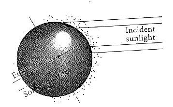
B. In polar areas the sun's ras strike the Earth in an olique manner and deliver less energy than at tropical locations for two reasons
1. The energy is spread over a larger surface nearer to the poles.
2. The energy passes through a thicker layer of absorbing, scattering and reflecting atmosphere.
C. Seasonal variation (Fig 40.1 in Gould & Keeton).
1. Earth's inclined axis of rotation (23.5 degrees) causes increasing seasonal variation in temperture and day length with increasing latitude.
2. When perpendicular to tropic of cancer, it is the summer solstice in Northern hemisphere. Perpendicular to tropic of capricorn when summer in Southern hemisphere (our winter solstice).
D. Global temperature differentials create winds and drive atmospheric circulation.
1. George Hadley in 1735 proposed that solar energy drove winds which in turn influenced the circulation of the atmosphere. He proposed that the large temperature contrast between the very cold poles and the hot equator would create a thermal circulation. The warmth at the equator caused the surface equatorial air to become buoyant and rise vertically into the atmosphere. As it rose away from its source of heat, it cooled (gas expands due to lower pressure) and became less buoyant but was unable to sink back to the surface because of the warm air behind it. Instead, it spreads north and south away from the equator, eventually returning to the surface at the poles. From there, it flowed back toward the equator to close the circulation loop. Hadley suggested that on a nonrotating Earth this air movement would take the form of one large convection cell in each hemisphere..
2. Two modern additions to Hadley's model.
a. Rather than two-cells as Hadley proposed, a six cell model actually fits the heat balance of the Earth better.
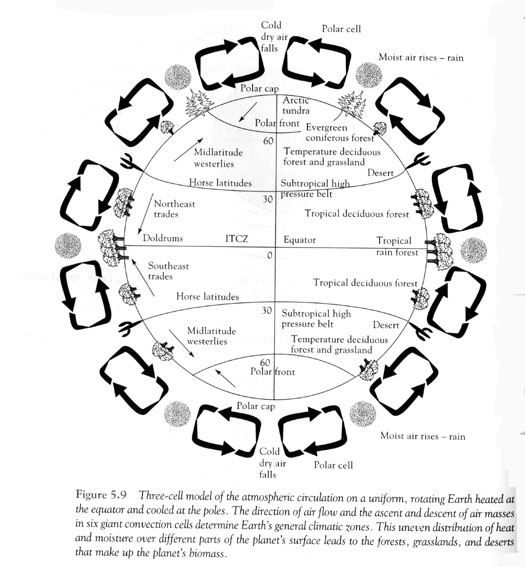
b. Rotation of earth causes the surface flow within the cells closest to the equator to become somewhat towards the west (the Coriolis effect). In any one revolution of the Earth, any point on the equator circumscribes a greater circle than any point to the south or north. Thus the equator is moving fastest during rotation (40,000 km/day vs 0 at the poles).
II. Moisture.
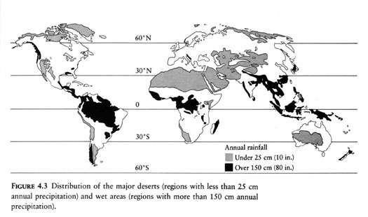
A. Warm air (gas) holds more moisture than cold. As air above the equator rises, it cools and is unable to hold all of the moisture--so it rains at the equator, creating the climate and moisture conducive for tropical rainforests (known as the intertropical convergence). The air that rises at the solar equator descends near 30 degrees N or S. Condensation has already removed much of its water as precipitation in the tropics, and its capaciaty to evaporate and hold water increases further as it sinks and warms. As the air mass strikes the ground in subtropical latitudes and spreads to the north and south, it draws moisture from the land, creating zones of arid climate centered at latitudes of about 30 degrees north and south of the equator. The great deserts--the Arabian, Sahara, Kalahari, and Namib of Africa, the Atacama of South American, the Mohave, Sonoran, and Chihuahuan of North American all fall within these belts.
B. Seasonality in moisture.
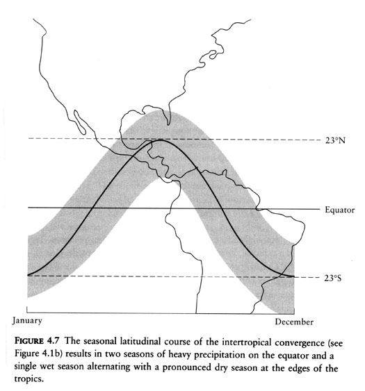
Because of the inclination of the earth's axis, the solar equator varies throughout the year from the tropic of cancer to the tropic of capricorn, therefore the belt of precipitation also varies. Near the equator, there are two seasons of heavy precipitation whereas at the edges of the tropics there is a single wet season followed by a dry season.
III. Ocean currents
A. The oceans move in response to the surface winds, creating movements or ocean currents--pinwheels known as gyres around the continents. The Gulf stream brings warm water from the Caribbean and the US coasts to Europe. The Humboldt current provides incredibly productive biological community--as evidenced by the abundant fish and the huge seabird colonies that thrive on these. Each year, a warm countercurrent flows down the Humboldt current and brings heavy rains.
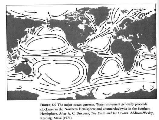
B. Irregular fluctuations in climate cause dramatic effects. El Nino-Southern Oscillations. During a typical year, a steady wind blows across the equatorial central Pacific Ocean from an area of high atmostpheric pressure centered over Tahiti to an area of low pressure centered over Darwin, Australia. An El Nino event appears to be triggered by a reversal of these pressure areas (Southern Oscillation) and of the winds that flow between them. As a result, the westward-flowing equatorial currents stop or may even reverse; upwelling off the coast of South American weakens or ceases; and warm water--the El Nino current piles up along the coast of South America. These ENSO (El Nino-Southern Oscillations) events cause major disruption to fisheries, kelp beds, mortality of coral and reproductive failure of seabirds.
IV. Regional effects on climate and moisture.
A. Oceans and large lakes
1. Moderate temperature changes on nearby land compared to more interior because of the heat storage capacity and vertical mixing of water reduces temperature fluctuations. (Ex. Seattle vs Minneapolis in winter)
2. Change patterns of rainfall (coastal areas may be moister than places near the interior of continents, coast is closer to moisture source)
3. Move heat over the surface of the earth. Results in a cool, dry environment along the west coast of S. American, vs a mild climate into western Europe and British Isles.
B. Rainshadows. The presence of mountains force air to rise causing it to cool and release moisture. Dry air flows over the mountains descends becoming warmer and absorbing moisture. The result is that the windward side of mountains are typically moist whereas the leeward side are more desert like. (Olympics vs eastern Washington)
V. Physical factors affecting aquatic biomes.
1. Nutrient and oxygen vary with temperature and depth in an aquatic ecosystem and also exhibit seasonality.
2. Seasonal cycles in lakes.
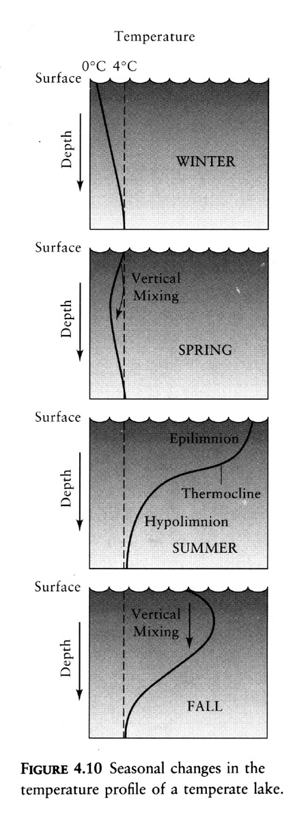
a. In winter a typical temperate zone lake has an inverted temperature profile. The coldest water (0 degrees) lies at the surface. Water is densest at 4 degrees C.
b. In early spring water temperature increases as sun warms the surface, and these waters sink into the cooler layers below. This vertical mixing distributes heat throughout the water column, resulting in a uniform temperature profile. Without the thermal layering, winds can cause the vertical movement of water in early spring, and bring nutrients to the surface from the sediments and bring oxygen from the surface into the deeper areas.
c. Later in the spring, the air above the lake warms, surface layers of water gain heat faster than deeper layers, creating a zone of rapid temperature change at intermediate depths, called a thermocline, and across the thermocline, layers of water do not mix and there is stratification. The warmer surface water literally floats on the heavier, cooler water below. The consequence is that most of the primary production of a lake occurs in the upper layer where sunlight is intense. Oxygen enters into the system as a byproduct of photosynthesis, and therefore animals can survive in this upper layer; however, the plants often deplete their mineral nutrients and curtail their own production--so plants become nutrient limited in the upper layer. Below, aerobic organisms deplete oxygen, and curtail their existence. Lower layer is oxygen limited.
d. During the autumn the surface layers cool more rapidly than the deeper layer and become heavier and begin to sink. This vertical mixing persists into late fall until the surface temperature drop below 4 degrees C and winter stratification occurs. Fall overturn speeds the movement of oxygen to deep waters and pushes nutrients to the surface.