Ground Truthing Survey
In the spring of each year, the Paynter Lab undertakes a survey of potential restoration sites. These sites are selected with the help of the Oyster Recovery Partnership, NOAA Chesapeake Bay Office (NCBO) and the Maryland Geological Survey (MGS). The survey has three steps, outlined below.
Step 1. Site Selection:
Sites are selected based on the available side scan sonar (SSS) data provided to the Paynter Lab staff by NCBO and MGS. The SSS data provide a picture of the targeted area based on the reflectivity of the bottom; harder bottom appears darker on the SSS picture while softer bottom is lighter. Below is a SSS image of Harris Creek.
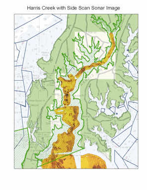
Figure 1. Side-scan sonar image of Harris Creek.
Darker areas are generally targeted for ground truthing survey work since oysters are more likely to growth and thrive on hard bottom. Once target areas are chosen, 10-acre target sites are created using spatial mapping software.
Step 2: Diver Survey
Once sites are selected, a diver survey of each site is conducted. This survey involves deploying a transect line through the site that is marked with tags every two meters. Transect lines are 50, 100 or 200 meters in length, depending on the size of the site. Below is a picture of the transect line underwater, as seen through the diver’s eyes:
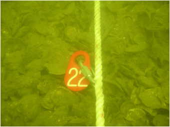
Figure 2. Image of ground truthing survey transect line. Lines are marked with numbered tags every 2 m.
Divers collect quantitative data about the bottom at each tag (every 2 meters). Data collected includes amount of exposed shell, primary and secondary substrate type and hardness, as measured by penetration. In an effort to standardize the data collection process between divers, specific responses for each data type are created for the diver to choose from. Below is a table outlining the responses and their associated data values for each data type.
Table 1. Observations recorded at each marked point along a transect line (every 2 m).
Exposed Shell |
Value |
Substrate Type |
Value |
Penetration (cm) |
Value |
Zero |
0 |
Silt |
0 |
70 |
0 |
Very Little / Patch |
1 |
Mud |
1 |
40 |
1 |
Some |
2 |
Sandy Mud |
2 |
20 |
2 |
Exposed |
3 |
Sand |
3 |
10 |
3 |
Oyster Bar |
4 |
Rock / Bar Fill / Debris |
4 |
5 |
4 |
|
|
Shell Hash |
5 |
0 |
5 |
|
|
Loose Shell |
6 |
|
|
|
|
Oyster |
7 |
|
|
* Increasing metric values show bottom type improvement
Step 3: Data Analysis
Once the diver survey is completed, the transects are designated as one of three bottom categories (Good, OK, Bad) in order to determine the appropriateness of each site to receive a spat-on-shell planting. The bottom type category was determined as the category within which two of the three data types (exposed shell, substrate type and penetration) fell. The table below outlines the requirements for each bottom type categorization.
Table 2. Summary of bottom type categorization--each transect surveyed is designated as good, ok, or bad bottom for spat-on-shell planting.
|
Exposed Shell Range |
Substrate Type Range |
Penetration Range |
Good Bottom |
3-4 |
4-7 |
5 |
OK Bottom |
2 |
3-4 |
3-4 |
Bad Bottom |
1-0 |
0-2 |
0-2 |
After the transects are scored, a map of each site is created and target areas for planting are determined based on the type of bottom under each transect. Below is a picture of the ground truthing survey at Strong Bay in 2011.
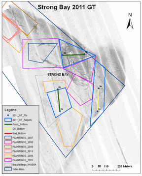
Figure 3. Example map of target sites recommended for planting based on ground truthing surveys. Blue polygons with lines inside represent target sites qualified as good (green line) or ok (yellow line) for planting.
For more specific ground truthing data inquiries please email us at: paynteroysterlab@gmail.com